


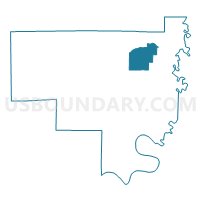
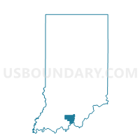
LIBERTY 02, Crawford County, Indiana
About
Outline

Summary
| Unique Area Identifier | 576718 |
| Name | LIBERTY 02 |
| County | Crawford County |
| State | Indiana |
| Area (square miles) | 9.13 |
| Land Area (square miles) | 9.13 |
| Water Area (square miles) | 0.00 |
| % of Land Area | 100.00 |
| % of Water Area | 0.00 |
| Latitude of the Internal Point | 38.34582360 |
| Longtitude of the Internal Point | -86.36254680 |
Maps

Graphs
Select a template below for downloading or customizing gragh for LIBERTY 02, Crawford County, Indiana


Neighbors
Neighoring Voting District (by Name) Neighboring Voting District on the Map
- LIBERTY 01, Crawford County, IN
- STERLING 02, Crawford County, IN
- STERLING 03, Crawford County, IN
- WHISKEY RUN 01, Crawford County, IN
- WHISKEY RUN 02, Crawford County, IN
Top 10 Neighboring County Subdivision (by Population) Neighboring County Subdivision on the Map
- Liberty township, Crawford County, IN (1,990)
- Whiskey Run township, Crawford County, IN (1,911)
- Sterling township, Crawford County, IN (1,635)